This is something Bob has been excited to do and I've held out for 2 years but finally gave in. For some reason, an old fashion steak cookout doesn't thrill me as a vegetarian, but I'll go along with it once!
Bob's main desire was to ride a horse out to the cookout rather than the wagon but the date we could book the trip, the horses were all taken or the kid who booked it didn't have a clue. Either way, it worked out for the better.
Here we are loading on the wagons.
These are the wagons after we have unloaded at the Yancey Hole Cookout Area. It has a history dating back to the 1800's and has been used for the cookout since about 1929.
The afternoon/evening started out well enough and while we piled our plates full of food (I had a prearranged veggie burger) these 2 'cowboy's' were singing under this little platform.
And then it started to rain...and rain...and rain. Rather than run for the large pavilion, we took refuge under the huge fir trees and they provided enough break for us to finish our dinners.
Now the funny part (in our minds at least) happened. There was a group on horseback that took a 2 hour ride earlier and wound up at the cookout first to eat dinner and then a 1 hour group of riders came after that to eat.
Our wagons held the last of the guests to get in to eat.
So about this time, the wranglers called for the 2 hour riders to go to their horse and get up to ride back. And after they left the 1 hour riders were called. It's along this time Bob decided he was happy enough riding the wagons. And yes, it was still raining.
Doesn't this look like fun now? Do you see the empty tables?
Before we left, there were some fun songs under the large pavilion and story telling.
A tradition as the wagons leave is each wagon circles around by the cooks to tell them thank you. We sang "The Sun Will Come Out Tomorrow" to them and they tipped their hats to us.
And as we pulled back up to the corral, the rain went away. It was fun, it's been done, and Yancey's Cookout Area will show up in a future post.
We love to travel and after 48 years of working and family life we are out and about on another adventure. Please join us as we post pictures and updates! Note: To see the pictures better, click on one and they will all be there, enlarged for easier viewing.
Numbers 6: 24-26
The Lord bless you, and keep you; The Lord make His face shine on you, And be gracious to you; The Lord lift up His countenance on you, And give you peace. Numbers 6:24-26
Tuesday, September 5, 2017
Monday, September 4, 2017
Sheepeater's Cliff
This is a favorite for us, it's easy and provides wonderful views. We were able to introduce the whole area to Phyllis this year. She told us about several new hikes so it was good to be able to take her to one she hasn't seen.
Unlike the implication of the name, the Shoshone Indians didn't kill the sheep to eat, but to harvest their horns for weapons.
If the horns and bones were soaked in hot water, provided by the surrounding hot springs, they became very pliable and could be stretched and molded to make a bow (as in bow and arrow).
The Shoshone were the last of the local tribes to adapt to using horses so they would herd the sheep into this natural cove in order to make the kills.
The above picture is a half round basalt ring taken from the entry point. This next picture shows the same area from above. We climbed up the left side and followed a semi path all the way around the top.
We wondered why so many of the rocks are hexagon shaped. Phyllis took a course on the geology of the park and was told this is the least stressful shape on the lava when it is cooling. The cooling starts from the top and works down, and the column below chooses the path of least resistance. If the top starts as this shape, it will follow below as the cooling continues.
Then we climbed back down to the parking lot and walked along the Gardiner River away from the immediate cliffs.
There is a good bit of forested area to walk under but when there is a view, it is the river on one side and more basalt cliffs on the other.
And here is our reward...the Cascades Waterfall.
At the base of the falls Bob and Phylllis found these bones through their cameras. We suspect a cougar pulled this section away from a carcass and brought it there to eat in peace.
This is a great shot from the vantage point we had.
Then as you rotate to look down river, there is this beautiful valley of Willows all over it. We were sure there was a moose down there watching us look for it and laughing!
The hike is about 1/2 mile out through fairly dense underbrush and back the same way. We walked on about another 1/2 mile following an animal trail but it disappeared so we turned back.
Wednesday, August 30, 2017
Bunsen Peak...old and new
This hike is one we do to acclimate to the elevation. Kathy decided to join us this time. We've always gone up the front and down the same way but had been told that going down the back side was beautiful so we decided to branch out this time.
Wildlife was in abundance if you count the little guys...1 lb or less. Here is a pretty, plump grouse that was weaving through the brush by the path.
And this little ground squirrel was daring us to pick and eat one of his berries. We did eat the berries on several of our hikes but not in front of him. They are wild raspberries, just as tasty and yes, we left some for the animals.
This is looking back NW to Mammoth Hot Springs. You can see how the smoke from fires outside the park has clouded the air. Most of August has been like this.
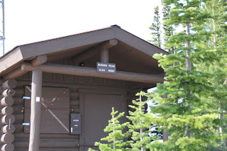
We made it to the top and sat down for lunch. This sign says Bunsen Peak, Elevation 8564'
By now the temperature has gotten up to 80+ so we are wrapping jackets around us and stuffing extra clothing in packs.
This ground squirrel has most definitely been fed by well meaning individuals. It is fat enough to make it through the winter. He wound up on Kathy's pant leg but we didn't feed him.
Down the back side of the mountain we go. This type of rock is called 'scree.' I don't know the origin of the name but it must mean 'small rocks that can make you easily fall so be careful to pick your way slowly down through them.' Actually, the back side of the mountain had much more scree than the front ever has. Not a favorite so far.
Below is the Gardiner River. Osprey Falls trailhead starts at the end of the mountain trail. See last year's post for more on OF. That's one I won't be doing again!
As we got out of the scree, we went into the new forests. This is as high as any of the new trees growing that we've seen since the 1988 fires. Seasons for growing are so short and winters so tough that they take a long time to come up.
We are almost down to the road that will lead us another mile back to the car. Still pretty views as we walk.
And this is the last of the wildlife...ducks on the pond.
Even though this was a 7 mile hike, it seemed like 15, ha! We will stick to the front side up and down from now on.
Friday, August 25, 2017
Grebe Lake - New Hike
Bob bought the Yellowstone fishing license to try his hand at fly fishing. Grebe was a lake recommended so we read up on it and drove out to do the hike and let him fish.
There's nothing like a bison jam when you want to make it from point A to B within a reasonable amount of time in YS. And the front vehicles are afraid to move.
Funny side story: Last week one of the Yellowstone Forever buses was gored by a bull bison. We saw the picture of the tire. He put his whole horn in one on the back. There was quite a flap of rubber you could pull back.
Our 'boss' is also the fleet manager and had to drive another bus out for the driver to continue and said he put the jack on and would pump twice then have to jump back in the bus to let more bison walk by. Took him awhile to change the tire :)
Back to Grebe. The description is for a mostly flat hike approximately 3.3 miles in. It is one of the best spots to find Arctic Grayling outside of Alaska.
3.3 miles is quite a way to haul heavy waders along with all the fishing gear and back packs so we didn't bring them.
We got to the lake after about 90 mins and immediately saw its a very marshy area. No waders, no real fishing. Sigh. Bob gave it a try in a few places and when his hook caught in a tree, he silently packed it up.
Here are some action shots. What you can't see are the 2 fishermen with waders out in the water. They caught several small Graylings and a few rainbow trout. (YS is catch and release with a few special exceptions).
We sloughed through the marshland to the downed tree line you can see here.
This swan was not worried about us in the least so we got some nice pictures of it.
That is also where we ate lunch. Again, not a bad view.
Grebe Lake with Wolf Lake make up the headwaters of the Gibbon River, the start of one of the longest waterways in the world.
The Gibbon flows into the Madison River, which flows into the Missouri River, which flows into the Mississippi River to cover over 3,500 miles once it hits the salt water of the Gulf of Mexico.
We have decided we've had more than a lifetime of hikes through the 1988 lodge pole pine fire that ravished the park. Here's what a good bit of the hike looked like. But it was a pretty day and adding in the walk around more than half of the lake we a total of 8 miles.
Another item we didn't carry in was Bob's camera so these shots are from my iPhone.
Wednesday, August 23, 2017
Knox Lake - New and Improved!
Bob and I did this hike last year and found out that where we stopped was not Knox Lake, but another smaller one. So this time we hiked with Carla, Kathy, Mary and Phyllis and came close to not even getting to make the hike. There were 2 cars of us, Phyllis driving her SUV and Bob and I were in our truck. We made it close to the trail head but there was a gate open we didn't remember before so Phyllis turned up into that road.
Keep in mind that it had been a year or in some cases 2-3 years since any of us had been here, and with no service for the phones, it was the blind leading the blind on the road to nowhere! As we found out later, Bob and I were saying 'they must know something we don't' and they were saying 'surely Bob and Barb would signal us if this isn't right.' After about 2 miles of severely bumpy, rutted road, Phyllis stopped and they all piled out. This is the funniest picture so far for this season!
What they were seeing was a large rut full of mud that she refused to go thru...for good reason! We helped her turn around and get by us and then we turned the truck around (methodology was scissor turns...2' forward, turn, 2' back, turn, etc) but we did it and in going on the other road found the trail head. I don't believe any of us will make that mistake again.
And so we were off. Due to late snow melt and rains, the water was running strong. This was our first look at the Bear Creek that flows below.
The big fun for the day was traversing several of the creeks flowing downhill. Half of the group walked across logs and the rest across the bed over rocks hoping to not sink below our shoes.
This was a good bit of the look of the path we walked along. At each turn you yell 'Hey Bear, Bear, Bear.' We practiced Indian whoops, talking loudly and singing silly songs along with the constant chatter of 5 women walking along a path!
Bob taking a picture of the field of Harebells. There are so many flowers around this year, its been exciting to see and identify the varieties still in bloom.
This is a little, double pond formed from run off. It appears to be larger last year.
Another crossing. I'm in the middle of the water as I have no confidence walking on logs. There's always the 2 options, log or water. The Forestry Service fixes a log or two from the downed trees. And in some cases there are nice bridges they've constructed.
And here is the lake that Bob and I stopped at thinking it was Knox last year. They all said, 'oh no, go further!'
And here is the next lake that we would have stopped at thinking it was Knox Lake but Kathy said 'oh no, go further!'
Field of flowers between lakes.
And here is the official Knox Lake. The description was that of a large, turquoise lake. This picture does a good job of showing off the coloring. It may be due to algae bloom in the water, snow melt and/or the rocks in the bottom. When the wind is calm and sun shining, it's very pretty and unusual.
Knox Lake after we all had lunch.
You can see the coloring best at this type of angle with the camera. We could see it standing next to the water but the color wouldn't show in the shots as brilliant.
As we hiked back down we saw this baby chipmunk frozen in place and visibly shaking. He finally realized there was the option of running and hiding but not before we got about 50 pictures of him collectively. :)
Chipmunks, Ground Squirrels and birds were the only wildlife around. And so, another hike is done and now we don't have to do it again (we hope!).
Keep in mind that it had been a year or in some cases 2-3 years since any of us had been here, and with no service for the phones, it was the blind leading the blind on the road to nowhere! As we found out later, Bob and I were saying 'they must know something we don't' and they were saying 'surely Bob and Barb would signal us if this isn't right.' After about 2 miles of severely bumpy, rutted road, Phyllis stopped and they all piled out. This is the funniest picture so far for this season!
What they were seeing was a large rut full of mud that she refused to go thru...for good reason! We helped her turn around and get by us and then we turned the truck around (methodology was scissor turns...2' forward, turn, 2' back, turn, etc) but we did it and in going on the other road found the trail head. I don't believe any of us will make that mistake again.
And so we were off. Due to late snow melt and rains, the water was running strong. This was our first look at the Bear Creek that flows below.
The big fun for the day was traversing several of the creeks flowing downhill. Half of the group walked across logs and the rest across the bed over rocks hoping to not sink below our shoes.
This was a good bit of the look of the path we walked along. At each turn you yell 'Hey Bear, Bear, Bear.' We practiced Indian whoops, talking loudly and singing silly songs along with the constant chatter of 5 women walking along a path!
Harebell |
Bob taking a picture of the field of Harebells. There are so many flowers around this year, its been exciting to see and identify the varieties still in bloom.
This is a little, double pond formed from run off. It appears to be larger last year.
Another crossing. I'm in the middle of the water as I have no confidence walking on logs. There's always the 2 options, log or water. The Forestry Service fixes a log or two from the downed trees. And in some cases there are nice bridges they've constructed.
And here is the lake that Bob and I stopped at thinking it was Knox last year. They all said, 'oh no, go further!'
And here is the next lake that we would have stopped at thinking it was Knox Lake but Kathy said 'oh no, go further!'
Field of flowers between lakes.
And here is the official Knox Lake. The description was that of a large, turquoise lake. This picture does a good job of showing off the coloring. It may be due to algae bloom in the water, snow melt and/or the rocks in the bottom. When the wind is calm and sun shining, it's very pretty and unusual.
Knox Lake after we all had lunch.
You can see the coloring best at this type of angle with the camera. We could see it standing next to the water but the color wouldn't show in the shots as brilliant.
As we hiked back down we saw this baby chipmunk frozen in place and visibly shaking. He finally realized there was the option of running and hiding but not before we got about 50 pictures of him collectively. :)
Chipmunks, Ground Squirrels and birds were the only wildlife around. And so, another hike is done and now we don't have to do it again (we hope!).
Subscribe to:
Posts (Atom)